Anna’s Hiking and Adventure Guide to Joshua Tree, CA
- Anna Schmitz
- Jan 5, 2023
- 7 min read

Updated: Jan 6, 2023
"Where two deserts meet. Two distinct desert ecosystems, the Mojave and the Colorado, come together in Joshua Tree National Park. A fascinating variety of plants and animals make their homes in a land sculpted by strong winds and occasional torrents of rain. Dark night skies, a rich cultural history, and surreal geologic features add to the wonder of this vast wilderness in southern California" (NPS).

This year, my family spent 6 days for Christmas in the town of Joshua Tree, CA about 1/4 mile from the entrance to Joshua Tree National Park. Our Airbnb backed up to the Mojave Desert Land Trust. This post will contain logistics of visiting the park and other areas of interest, recommendations for hiking (both in and out of the park), shopping, lodging, off-roading options, stargazing tips and food.
JTNP Logistics: Peak visiting months are typically October through May, when the temps are much cooler. This means LOTS of people. More people enter the park through the West Entrance Station off Qual Springs Rd. Starting at about 9am, the line to enter the park can get very long. For this reason, we opted to enter the park through the North Entrance, in Twentynine Palms. The least crowded entrance is the South Entrance near the Cottonwood Visitor's Center. However, this means you are much further away from a lot of the popular sites that JTNP is known for (Skull Rock, Cholla Cactus Garden etc.). We visited the Visitor Center in downtown Joshua Tree and it was packed with people. Due to the crowds, we tried the Oasis Visitor Center. This is actually no longer a 'visitor's center' but the bathrooms, store and trail through the Oasis of Mara are still open. The trail is about 0.5 miles, paved, wheelchair accessible and dog friendly. It is lined with informational markers about the history and flora of JTNP and the Oasis of Mara. It was much less busy, and in my opinion, better than the main visitor's center.


A list of all of the visitor's centers can be found here.
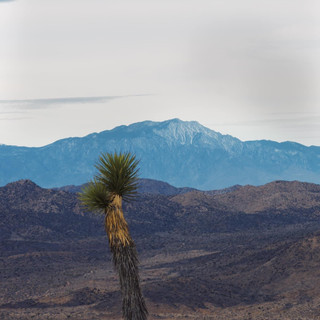
Cholla Cactus Garden: The garden is located along the Pinto Basin Road. This area can get fairly busy. We stopped along the side of the road just north of the parking area. This is a quick stop to get out and look around the garden. Be aware of where you walk. The cactus quills WILL stick into your shoe. Also stop by the Ocotillo Patch, just south of the Cholla Cactus Garden.


Ocotillo Patch:

Hikes:
• Quail Wash, Mojave Desert Land Trust: this trail is not on AllTrails and I'm not even sure it is an actual "hike". It is very long and intersects with the Bigfoot Trail and crosses over into the National Park, about 1.5-2.0 miles in, depending on where you begin. It is a flat trail and can be accessed from Uphill Road (a dirt road), off of Quail Springs Road. The coordinates are: 34.09217° N, 116.28332° W. This is a fun place to wander around and explore. Dogs are allowed on the MLT, but not in the park.


• Ryan Mountain: located in Joshua Tree National Park. This is one of the most popular trails, so starting early is recommended. I got to the trailhead around 8am and there were only a few other cars. The hike is steep. 2.95 miles RT and 1,100ft elevation gain. The first mile gains about 750ft. The last 0.44 miles gains the remaining 350ft. It took me 1hr 22min in total, but can take an average of 2hrs to complete. Ryan Mountain stands at 5,456ft above sea level. Dogs are not allowed on this trail.


•Lost Horse Mine: an old abandoned Gold Mine located in JTNP. I was the first car to arrive at 8:10am, lot was full upon my return around 9:30am. I did an out-and-back hike that was 4.2 miles RT and 684ft elevation gain. This hike can also be made into a longer 6.2ish mile loop. Dogs are not allowed on this trail.


•Warren Peak, Black Rock Canyon: the trailhead is located right near the edge of the Black Rock Canyon Campground. Total distance was 5.93 miles and 1,100ft elevation gain. The first 2 miles you gain around 500-600ft. The last 0.75ish miles you will gain the remainder of the elevation. The first mile is softer sand, while the remainder of the hike is packed sand. Dogs are not allowed on this trail.


•Fortynine Palms Oasis: Located in 49 Palms Canyon on the north side of Joshua Tree. 3.2 miles RT and 737ft elevation gain. The first 0.75ish miles are up hill about half of the elevation, the rest will take you downhill into the Oasis. This means you will have to hike back up on the way back for about 0.75 miles and then the trail will take you downhill back to your car. There is NO shade on this hike. Recommend to go earlier in the morning. Dogs are not allowed on this trail.

•Heart Rock & Arch Rock: Hike to a rock formation known as "Heart Rock" with an option to add on "Arch Rock". Be warned, this trail is PACKED. I hiked to Heart Rock and then back from the side of the road along the marked trail. It's hard to miss. Just follow the crowds of people. About 1.27 miles and 127ft elevation gain depending on where you begin. Dogs are not allowed on this trail.


•Hall of Horrors: This is a popular area for climbing. There is a 0.6 mile loop around the rock formations. Walk the trail or scramble on the giant boulders. This is also a very busy and popular spot.

Watching the climbers. JTNP contains thousands of mapped climbing routes. Some of the most in the world. December is considered the best climbing weather.


•Big Morongo Canyon Preserve Marsh Trail: Big Morongo Canyon Preserve is part of the Sand to Snow National Monument. They have extensive wheel chair accessible trails. The Marsh Trail is seen on the map in the link above, in green. You can read about this specific trail here. It is 0.65 miles RT, has minimal elevation gain and is fully wheelchair accessible. No dogs are allowed in the reserve.


•Whitewater Preserve: This is also part of the Sand to Snow National Monument. They have lots of trails, including an access point to the PCT. Here, we did the paved path in front of the visitor center and then took a short walk to the "River Access" point. Please note that the river has almost dried up as of April 2022. It still has some water flowing and you can walk accross it's entirety. Both trails were minimal in distance and elevation gain, however I highly recommend visiting this location, as it was my favorite. Dogs are also allowed. It is free to enter the park, but is subject to flooding. Check their Instagram for updates. They also frequently hold free guided hikes.


Off-Road Routes:
La Contenta Road to Covington Flats & Eureka Peak: 4-wheel drive beneficial along this route but not necessary. Follow La Contenta Rd and signs for Covington Flats. Almost at the end of the road, there will be signs for a picnic/photo area. Turn right here. You will get to another road with signs for Eureka Peak. Turn right here, and follow to the end to reach Eureka Peak. Escape the crowds and get some of the best views in the park.


Queen's Valley: Well-maintained dirt road in JTNP. 4-wheel drive not necessary. Watch for bikers and hikers along this route.


Shopping:


These are just some of the shops we stopped at. Wander around 29 Palms Hwy in Joshua Tree or Twentynine Palms and you'll find tons of great and locally owned shops.
•Sun of the Desert: 61729 29 Palms Hwy, Joshua Tree, CA. Open Mon-Fri 10am-4pm, Sat & Sun 10am-6pm


•Black Luck Vintage: 7350 Acoma Trail, Yucca Valley, CA. Open Thurs-Mon 10am-5pm
•White Label Vinyl: 73517 29 Palms Hwy, Twentynine Palms, CA. Open Thurs-Mon 11am-6pm
•HI Desert Daydream: 73515 29 Palms Hwy, Twentynine Palms, CA. Open Mon-Fri 12pm-6pm, Sat & Sun 10am-8pm
•The Station: 61943 29 Pam's Hwy, Joshua Tree, CA. Open Thurs-Mon 10am-6pm

Stargazing:
JTNP is a National Dark Sky Park. Summer is the best time to see the Milkyway, but all seasons are great. In Winter, you can see the Gemini constellation, Sirius, Orion and the Taurus constellation (among other things). Click here to read more about stargazing in JTNP.
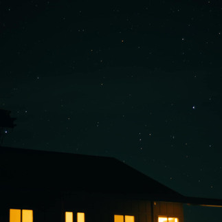
If you want to get crisp photos of the stars at night, bring a tripod (which I forgot to do...). Here are some of the (not crisp) shots I got inside the park, in the Quail Springs parking lot/pull off area.


Since we had our dog along, we had an astronomer come to our Airbnb and teach us about the night sky. We booked through Joshua Tree Excursions. We got to look at the moon, Mars, Jupiter, Andromeda, the Dog Star, Gemini, Cancer, the Big Dipper and more.

Photo of the moon through the telescope.

I was also able to get more crisp shots of the stars, as it was clearer and I found a good chair to double as a tripod.


Food
•Red Dog Saloon: 53539 Mane Street, Pioneertown, CA. Open Mon & Thur 10am-10pm, Fri 10am-12am, Sat 9am-12am and Sun 9am-10pm. Dog friendly outdoor seating with heaters. Super casual street tacos, quesadillas & drinks. Try the Lightning Margarita!


•Edchada's: 73502 29 Palms Hwy, Twentynine Palms, CA. Dog friendly indoors and outdoors. Open Mon-Sat 11:30am-8:30pm and Sun 11:30am-7:30pm.


•Pappy & Harriet's: 53688 Pioneertown Road, Pioneertown, CA. Dog friendly patio, live music, expect to wait a minimum of 30min for a table - this place is often PACKED.
•Mojave Desert Charcuterie: Support a locally owned and woman-owned business and have a charcuterie board delivered to your vacation rental!
Lodging:
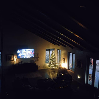
We stayed in the Joshua Tree Tower Ranch through Airbnb. The property consists of 4 bedrooms and 4 bathrooms. The backyard overlooks the Mojave Desert Land Trust. The property can be found here. This is a lovely space and I would highly recommend it to anyone planning to visit Joshua Tree. It is located approx. 0.3 miles from the parks west entrance. It has spectacular views and is a great spot for sunrise, sunset and stargazing. It is also dog friendly!
This photo was taken from the trails that are accessible right out the back gate.

L to R: Loft view, living room window view, out the back door


Enjoying a fire in the Chiminea.

L to R: Room I stayed in, backyard, from the loft looking into living room


Photos from sunrise captured on the property.


Oliver say's, "Thanks for stopping by!"

Happy hiking! And as always, Leave No Trace.
- Anna


Comments